Online or onsite, instructor-led live QGIS training courses in Brugge.
Bruges
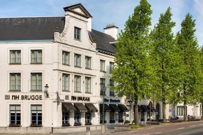
NH Hotel Bruges, Boeveriestraat 2, Bruges, Belgium, 8000
Bruges became a central port, commercial and financial hub in medieval Europe, linking the countries of the North Sea and ...
Bruges became a central port, commercial and financial hub in medieval Europe, linking the countries of the North Sea and the Baltic to the Mediterranean. Wealthy merchants from Bruges traded with those from all over Europe. The first stock exchange in history was born in Bruges in the 13th century. In the 15th century it was the leading financial center in Europe. This economic boom also leads to a cultural and artistic flowering that has left an abundant heritage. It was the most important center for the Flemish primitive painters, who revolutionized Western painting. It has been a member of the Organization of World Heritage Cities since the year 2000. The city even has the distinction of appearing three times on the UNESCO World Heritage List. For its historic center, for its beguinage which is part of the Flemish Beguinages and for its belfry included among the Belfries of Belgium and France. In addition, it is also listed as Intangible Cultural Heritage of Humanity by UNESCO for its Procession of the Holy Blood.
A geographic information system (GIS) is a system designed to capture, store, manipulate, analyze, manage, and present spatial or geographic data. The acronym GIS is sometimes used for geographic information science (GIScience) to refer to the academic discipline that studies geographic information systems and is a large domain within the broader academic discipline of geoinformatics.
QGIS functions as geographic information system (GIS) software, allowing users to analyze and edit spatial information, in addition to composing and exporting graphical maps. QGIS supports both raster and vector layers; vector data is stored as either point, line, or polygon features. Multiple formats of raster images are supported, and the software can georeference images. To summarize it allows the users to Create, edit, visualise, analyse and publish geospatial information on Windows, Mac, Linux, BSD.
This program, in its first phase, introduces the QGIS interface for general usage. In the second phase, we introduce PyQGIS - the python libraries of QGIS that allows the integration of GIS functionalities in your python code or your python application, so that you may even create your own Python Plugin around a particular GIS functionality.
Read more...
Last Updated:
Testimonials (1)
The trainer adapted the materials and contents to what he thought would be best for us and he succeeded. The quality of the training was excellent.
Online QGIS training in Brugge, QGIS training courses in Brugge, Weekend QGIS courses in Brugge, Evening QGIS training in Brugge, QGIS instructor-led in Brugge, Weekend QGIS training in Brugge, Online QGIS training in Brugge, QGIS coaching in Brugge, QGIS on-site in Brugge, QGIS instructor-led in Brugge, QGIS trainer in Brugge, QGIS boot camp in Brugge, QGIS one on one training in Brugge, Evening QGIS courses in Brugge, QGIS private courses in Brugge, QGIS classes in Brugge, QGIS instructor in Brugge